BEMAPS IS BORN: FLAWLESS MAPS IN JUST THREE STEPS
Result of the collaboration between University of Zaragoza and GEOSLAB
The University of Zaragoza and GEOSLAB have designed and developed BeMaps, a web tool for creating and sharing thematic maps quickly, easily and with impeccable results. It is an application that can be used by anyone, regardless of their experience, thanks to a friendly design that guides the entire cartographic elaboration process, while maintaining the highest standards of quality and technical rigor. In addition, this tool allows the user to decide on the privacy of the data used, an aspect of utmost importance nowadays.
Geographic information is currently experiencing a period of maximum relevance. Every day an immense amount of data is generated from administrative records (Municipal Register of Inhabitants, General Directorate of Cadastre, the Health System…), but it is also generated automatically through digital devices connected to the internet such as mobile phones, watches, cars, industrial equipment or sensors of all kinds that can measure everything from soil moisture, the availability of a public facility or traffic density. All these data have as a common link their reference to the place where they are generated, i.e. they are geolocalised data.
This geographical component adds a fundamental value to the information: context, for while it is important to know what is happening, it is even more important to know where.
In this sense, maps have proven to be a very effective communication tool for analysing and explaining reality and are increasingly used in all areas: in the media, research, teaching, citizen participation, public administrations and, of course, the business world.
The Study Group for Spatial Planning of the University of Zaragoza (GEOT-IUCA, http://geot.unizar.es/inicio/) and the Advanced Information Systems Laboratory group (IAAA-I3A https://www.iaaa.es/) have been working together for more than a decade on applied research in the field of geographic information from two complementary perspectives: geography and technology. During this time, they have tackled different challenges, focusing on the quality of the data and the maps that represent them.
There is a wide variety of software solutions on the market that allow the creation of maps, including the so-called GIS (Geographic Information Systems). However, no software could easily and quickly facilitate the design of thematic maps combining rigour and ease of reading, nor did it meet the data privacy demands required in many projects. For these reasons, it was decided to design a proprietary tool based on the knowledge and experience of GEOT and IAAA, and developed by the Aragonese technology company GEOSLAB (https://www.geoslab.com), created as a spin-off of the University of Zaragoza.
BeMaps meets three key requirements:
● Allows both people with and without experience in geographic data to create web maps in an agile way, bridging the significant GIS learning curve.
● It meets GEOT’s exacting standards in terms of design quality and appropriate use of cartographic language. The result is maps of great visual impact, easy to read and created with the highest scientific rigour.
● Ensures, at all times, control over data and data privacy. Although the BeMaps philosophy is “create and share your maps”, each person chooses whether their maps are public or not and how and with whom they share them. The data remains secure in your user area.
BeMaps will be implemented as the University of Zaragoza’s own tool and will be used for teaching and research as well as for management.
All information about BeMaps is available at www.bemaps.es.
Contact person:
María Zúñiga, Dept. of Geography and Spatial Planning, UNIZAR (mz@unizar.es)
Susana Zarazaga, GEOSLAB (suzarso@geoslab.com)
Useful links:
BeMaps https://app.bemaps.es/
Web https://bemaps.es/
Examples of maps:
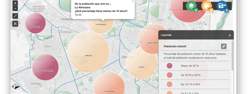
Where do children live?
https://app.bemaps.es/user-map/652d6cd7e629210401a1a19c/view
Accessibility to buildings
https://app.bemaps.es/user-map/65380f04e6292104010baf2a/view
Getting around the city of Zaragoza by bus
https://app.bemaps.es/user-map/653f7a43e6292104010baf65/view
Foreign population in Spain
https://app.bemaps.es/user-map/652d7b78e629210401a1a1ea/view

